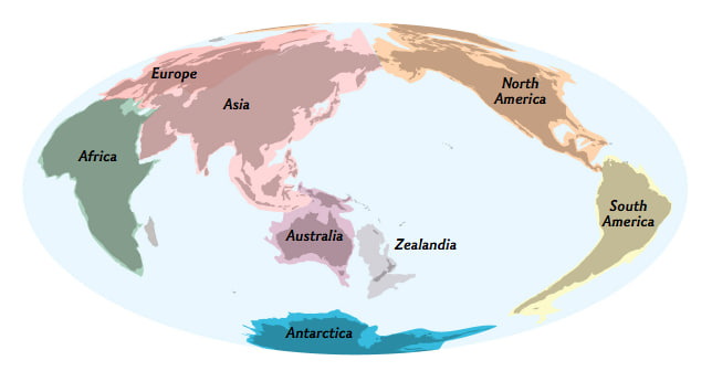
The lost continent of Zealandia has been mapped for the first time
Pancake Rocks on the west coast of the South Island of New Zealand. The island country is the tip of a vast, submerged continent called Zealandia—and scientists have finished mapping the whole thing. After years of exploration and research, scientists have finished mapping a sunken continent that lurks beneath the South Pacific. This chunk of continental crust, driven to the depths millions of years ago, is known as Zealandia, or by the Indigenous Māori name Te Riu-a-Māui. By piecing together rock samples with magnetic maps, geologists have revealed the extent of Zealandia, hidden below the ocean surrounding New Zealand. Seven years ago, geologist Nick Mortimer and colleagues revealed the existence of this mostly submerged continent, and in 2021 they mapped the southern portion. continue... https://www.nationalgeographic.com/premium/article/the-lost-continent-of-zealandia-has-been-mapped-for-the-first-time
Comments
Leave a Comment